History’s Deadliest Earthquake in Shaanxi 1556, Leveled Mountains and Reversed Rivers

History’s Deadliest Earthquake in Shaanxi 1556, Leveled Mountains and Reversed Rivers

Khalid Elhassan - October 13, 2018

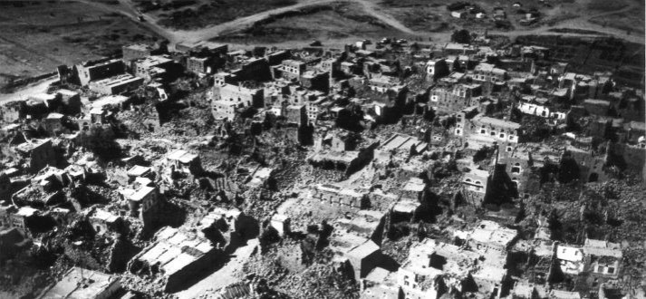
The Loess Region is the cradle of China’s civilization. It is also a region particularly vulnerable to earthquake damage because loess soil – rich windblown silt that settled over the millennia to depths of up to 300 meters – disintegrates easily when subjected to seismic activity. Between that vulnerability and China’s high population density, many of the world’s most devastating earthquakes have occurred in China. One such struck in 1556, when Ming Dynasty China was rocked by the deadliest earthquake in human history. Epi-centered in the Wei river basin in modern Shaanxi, the upheaval is estimated to have registered 8 on the Richter scale.

The earth split open with fissures up to 70 feet deep, as the ground suddenly rose up in some place to form new hills, while in other places hills crumbled and subsided into valleys. 97 counties in Shaanxi and surrounding provinces were devastated, as the earthquake destroyed nearly everything within an area more than 500 miles wide, and damage was inflicted as far as 310 miles from the epicenter. Fatalities numbered in the hundreds of thousands, and the injured numbered in the millions.

History’s Deadliest Earthquake in Shaanxi 1556, Leveled Mountains and Reversed Rivers
Geology of China. Quora

China’s Shaanxi Province Was and Remains Particularly Vulnerable to Earthquakes

China’s Loess Region is a plateau covering about 250,000 square miles in the upper and middle Yellow River – so named because the loess forming its banks gave it a yellowish tint. The good thing about the region is that the soil that gave it its name and covers the ground in layers up to 300 meters deep, is great for farming. The pale yellow or buff loess sediment is formed by the accumulation of windblown silt comprised of crystals of mica, quartz, feldspar, and other minerals. It is porous, with small empty spaces in the soil that allows for excellent air circulation. It is also friable – that is, easy to break into smaller pieces – which makes it relatively easy to plough, requiring less time and effort from farmers working loess fields.

Such factors tend to make for very rich agriculture, and with the right climatic conditions – water, sun, and the right temperature – loess soil is some of the most fertile and productive terrain in the world. Much of China’s Loess Region has the right climatic conditions, and its rich and readily tilled earth acted like a magnet that attracted farmers since the dawn of the agricultural revolution. Eventually, as population density increased, the region became the cradle of China’s civilization.

However, one of the factors that make loess attractive to farmers and conducive to high population densities – the ease with which it breaks and crumbles – is also a vulnerability. Loose soil might be great for farming, but buildings erected atop it are particularly prone to tumbling down if the ground shakes. Unfortunately, the ground in the Loess Region has a tendency to shake.

According to plate tectonic theory, the earth’s crust consists of several plates floating on top of molten magma. As the tectonic plates slide over that magma, moving away from or colliding with each other, they produce earthquakes and volcanic activity. Most of China sits atop a major tectonic plate: the Amurian Plate, which is part of the Eurasian Plate. However, in an arc stretching around China and gripping it in a pincer, are the North American Plate, the Philippine Plate, and the Indian Plate, whose collision with China formed the Himalayas (see map above). As those plates converge upon China, they pinch and squeeze it from multiple sides, causing its crust to warp hundreds of miles away from the plate boundaries (see map below). That tectonic activity is why the world’s highest plateau is located in China, and why the world’s highest mountain, Mount Everest, is on China’s doorstep.

History’s Deadliest Earthquake in Shaanxi 1556, Leveled Mountains and Reversed Rivers
Plate tectonic pressures in China. Quora

The Loess Region, and Shaanxi province, in particular, are susceptible to warping from those tectonic plate pressures. Lying smack dab in the middle of historic China, Shaanxi and the surrounding region are constantly squeezed by the tectonic plates converging on the country, creating faults that lend themselves to energetic seismic activity. In other words, when the pressure builds up from tectonic plates pressing in on the one atop which China rests, it sometimes gets released hundreds, or even thousands, of miles away in Shaanxi, in the form of major earthquakes.

History’s Deadliest Earthquake in Shaanxi 1556, Leveled Mountains and Reversed Rivers
The Small Wild Goose Pagoda, whose top fell during the 1556 earthquake. My Veiling

The 1556 Shaanxi Earthquake

Early in the morning of January 23rd, 1556, Ming Dynasty China was rocked by a massive earthquake that was the epicenter in the Wei River Valley’s Huazhou District, in northern China’s Shaanxi Province. The resultant damage, across a region, stretching for hundreds of miles, was extensive, and the loss of life horrific. Because it occurred during the reign of the Jiaging Emperor, the earthquake is often referred to in traditional Chinese history as the Jiajing Earthquake. Today, it is more commonly known as the Shaanxi Earthquake of 1556. Whatever the designation, it proved to be the deadliest earthquake ever recorded in human history.

Although the upheaval lasted only for a few seconds, it leveled mountains, opened fissures up to 66 feet deep in the earth, altered the path of rivers, caused massive flooding, produced massive landslides, and ignited fires that lasted for days. Over half the population of Huazhou was killed, as every single home and building was destroyed in an upheaval that probably registered 8 on the Richter scale.

The situation in nearby Huayin and Weinan was similar. The mayhem spread far and wide, causing death and destruction at distances up to 310 miles away from the epicenter, and buildings were damaged as far away as Beijing and Shanghai There have been other earthquakes that registered far higher on the Richter scale, and that lasted for far longer. But none have ever killed as many people as did the Shaanxi Earthquake of 1556.

As described in the annals of China: “In the winter of 1556, an earthquake catastrophe occurred in the Shaanxi and Shanxi Provinces. In our Hua County, various misfortunes took place. Mountains and rivers changed places and roads were destroyed. In some places, the ground suddenly rose up and formed new hills, or it sank abruptly and became new valleys. In other areas, a stream burst out in an instant, or the ground broke and new gullies appeared. Huts, official houses, temples and city walls collapsed all of a sudden“.

History’s Deadliest Earthquake in Shaanxi 1556, Leveled Mountains and Reversed Rivers
Map of provinces affected by the 1556 earthquake. Wikimedia

In addition to significant loss of life, reaching into the hundreds of thousands, the earthquake caused significant cultural damage. The Small Wild Goose Pagoda, built in 709, lost its top floor and about 6 feet of height. China’s Stele Forrest museum, which housed a steadily growing collection of steles and stone sculptures since the 11th century, was badly hit, and many of its artifacts were damaged or destroyed. Most significant of those was a collection is known as the Tang Stone Classics, a group of twelve early Chinese classic works, about 650,000 characters in length, that were engraved on 114 stone tablets on the orders of a 9th-century emperor. 40 of those tablets were broken during the earthquake.

History’s Deadliest Earthquake in Shaanxi 1556, Leveled Mountains and Reversed Rivers
Loess cave dwellings in Shaanxi. ThingLink

Toll and Aftermath

Aftershocks continued for six months. In many counties within the earthquake’s zone of destruction, over 60% of the population was killed outright, with many of the remainder injured, and all the survivors were left without shelter. Fatalities were particularly high because most of the population in Shaanxi and surrounding regions, taking advantage of the soft loess soil, had built their homes out of earth shelters known as yaodongs – a form of artificial cave carved out of hillsides.

Such houses have the advantage of being cool in the summer and warm in the winter, but they had the disadvantage of being particularly vulnerable to seismic activity. When the earthquake struck, they collapsed, with not only the weight of a roof collapsing upon the inhabitants, but an entire hillside falling on and burying whole communities. When it was over, around 830,000 had been killed, and millions more were injured and/ or made homeless.

That made the 1556 Shaanxi Earthquake the deadliest earthquake ever, and the third deadliest natural disaster in history, exceeded only by the 1931 China floods, and the 1887 Yellow River flood. The cost of the damages caused by the Shaanxi earthquake is probably impossible to measure in modern terms. To put it in perspective, however, China at the time was the world’s wealthiest country, and the earthquake destroyed an entire region of its core, killing 60% of that region’s population. A modern analogy might be a natural disaster that destroyed America‘s Mid-Atlantic states and killed over half their population.

History’s Deadliest Earthquake in Shaanxi 1556, Leveled Mountains and Reversed Rivers
Traditional yaodongs, or cave houses, in Shaanxi today. Wikimedia

In the aftermath, the upheaval inspired searches for the causes of earthquakes in general, and the best ways to reduce the damage they cause. An example was the scholar Chin Qeda, who lived through the event and recorded its details. One of his conclusions was that: “at the very beginning of an earthquake, people indoors should not go out immediately. Just crouch down and wait. Even if the nest has collapsed, some eggs may remain intact“.

Additionally, local records indicate that the earthquake led people in Shaanxi and the other affected regions to search for ways to minimize the damage from similar upheavals in the future. For example, many of those killed had been crushed by falling buildings, so after 1556, many of the stone buildings that had been leveled were rebuilt with softer and more earthquake-resistant materials, such as wood and bamboo.

History’s Deadliest Earthquake in Shaanxi 1556, Leveled Mountains and Reversed Rivers
A consistent 8-meter fault scarp, dating from the 1556 earthquake showing where one side of the fault line rose relative to the other, can still be seen today. Earthquakes Without Frontiers

­­­­­­­­­­­­­­­­­­­____________

Where Did We Find This Stuff? Some Sources & Further Reading

Encyclopedia Britannica – Shaanxi Province Earthquake of 1556

Fancy Frindle – 1556 Shaanxi Earthquake: Deadliest Earthquake in History

Journal of Structural Geology, Volume 20, Issue 5, May 14th, 1998 – Geomorphological Observations of Active Faults in the Epicentral Region of the Huaxian Large Earthquake in 1556 in Shaanxi Province, China

New Historian – Deadliest Earthquake Hits China

Rafferty, John P. – Plate Tectonics, Volcanoes, and Earthquakes (2010)

Wikipedia – 1556 Shaanxi Earthquake

Wikipedia – List of Natural Disasters by Death Toll

Wong, David W. S., et al. – China: A Geographical Perspective (2018)

Advertisement