10 Military Invasions That Changed Global Map In The 20th Century

10 Military Invasions That Changed Global Map In The 20th Century

Stephanie Schoppert - February 24, 2017

The lines on the map have constantly changed since the earliest days of history, and the 20th century was no different. As countries changed, split apart, fought wars, and gained their independence, the lines on the map moved. In some cases, the map changed due to the aggression of another state, one that felt they had the rights to the land occupied by another country or a state that thought it would be easy to annex a country in turmoil. While the 20th century saw two world wars that were rife with invasions and drastically changed the map, there were plenty of other invasions that affected how the world saw itself as well.

10 Military Invasions That Changed Global Map In The 20th Century
Current borders and areas of conflict between Pakistan, India and China with the areas divided in 1949. Wikipedia

1947 Invasion of Jammu and Kashmir

In 1947 there was a territorial dispute between Pakistan and India over the Kasmir and Jammu region. Both India and Pakistan were made independent on August 15, 1947. Britain decided that the princely states would have to become part of Pakistan or India. The decision for whether a state would become part of Pakistan or part of India was based upon their location and their demographics. Most of the states were easy to determine whether or not they would be part of Pakistan or India. However, there were a few states that were not sure as to which country they would join, namely Kashmir.

Kashmir at the time was led by a Hindu Maharaja despite the fact that most of the population was Muslim. This made it hard for the Maharaja to decide which state to join, and the indecision became a source of frustration for pro-Pakistani groups in Kashmir. In October 1947, tribal rebellion broke out and by October 10, the Pakistani Army entered Kashmir to provide support to the rebellion.

Kashmir government forces fought against the rebellion and the struggle went back and forth and Pakistani forces also entered into the Jammu region. The Maharaja knew that he faced impossible odds and therefore he asked India for help.

India agreed but on the condition that the Maharaja would accede Kashmir to India. The Maharaja agreed and on October 26, the Instrument of Accession was signed. The Indian military entered Kasmir and began the first Indo-Pakistani war. The war lasted until January 1, 1949 when a ceasefire was signed. The ceasefire turned over the states of Jammu and Kasmir to India, but Pakistan was given a third of the state to control, the areas of Azad Kashmir and Gilgit-Baltistan. The territory still remains under dispute and other conflicts have been fough over Kashmir since the end of the first Indo-Pakistan war.

10 Military Invasions That Changed Global Map In The 20th Century
Map of India 1947 showing the Portuguese colonies that were ceded to India in 1961. James Alcock, Historical Atlas of the British Empire

1961 Indian Invasion of Portugal

In 1947, India became independent from Britain, however there were some areas on the Indian continent that were still held as colonies by the Portuguese; Goa, Daman and Diu, and Dadra, and Nagar Haveli. In 1950, the government of India spoke to the Portuguese government about the future of colonies, namely when they might be given their independence to incorporate into India. The Portuguese government responded that those areas were not colonies after all, but actually part of metropolitan Portugal. Therefore, transferring the colonies was not a possibility.

Throughout the 1950s, strife in Goa over the continuation of Portuguese rule increased. A massacre of peaceful Indian activists in 1955 and the Portuguese military firing upon an Indian passenger boat in 1961 (killing one passenger) increased support in India for military action to liberate the Portuguese colonies. In 1954, pro-Indian forces occupied Dadra and Nagar Haveili, two land-locked enclaves that were completely surrounded by Indian land. The Indian government refused to allow the Portuguese military to travel through their lands to put down the occupying forces in their colonies.

In 1961, both India and Portugal knew that armed conflict was on the horizon. Portugal built up their forces in Goa, made a plan for attempting to be a much bigger and stronger military force, and evacuated civilians. On December 11, 1961, Indian forces moved into Goa and both sides fought by land, air, and sea for the fate of the colony.

The United Nations debated and held a vote on December 17, 1961 on whether or not to intervene in a ceasefire, but it was stopped by Soviet Veto. On December 18, 1961, the Portuguese knew that they had lost and officially surrendered the following day. Under the terms of the surrender, Goa, Damon, and Diu were ceded to India.

10 Military Invasions That Changed Global Map In The 20th Century
Map of Cyprus from the CIA World Factbook displaying the outcome of the 1974 Turkish invasion

1974 Turkish Invasion of Cyprus

In 1960 the island of Cyprus was granted its independence from Britain and declared the Republic of Cyprus. The 1960 constitution ended up giving the Presidency to the Greek Cypriots and the Vice Presidency to the Turkish Cypriots, and both were given veto power. This was meant to protect the minority Turkish population. In 1963, constitutional amendments were proposed that would have taken much of the power and protections from the Turks in government. Violence flared, the 1960 constitution fell apart, and calls from the Cypriot leaders and the UN for peace failed.

The Turkish army contingent took over the most strategic spot on the island, the Nicosia to Kyrenia road which was the main road through the island. From then on, to use the road Greek Cypriots needed a UN convoy. The Turks started living in enclaves that were protected by the National Guard and supported by the Turkish government.

The Greek Cypriots responded by limiting their movement and access to supplies which led to the Turkish Cypriots fighting for more freedom of movement in 1967. The Turkish government threatened to invade on the basis of protecting their people from genocide if the problem was not solved.

In July 1974, the Greek military rose up and overthrew the government. The Turkish military invaded on July 20, in order to protect the Turkish Cypriots believing that the instability in Greece would affect Cyprus. On July 23, the military junta that had taken over Greece collapsed and democracy was restored. Peace talks still failed and the Turkish military began another operation in Cyprus on August 14. The Turkish military managed to occupy 40% of the island before a ceasefire was negotiated. The Green Line buffer zone by the UN was expanded to separate the Turkish Cypriots and the Greek Cypriots. The northern part of Cyprus is now administered by Turkish Cypriots while the rest of the island is under the control of the Greek Cypriot government.

10 Military Invasions That Changed Global Map In The 20th Century
Map Showing the 1947 Partition of India and the area of East Pakistan which became Bangladesh after the 1971 invasion. Indiegogo.com

1971 Indian Invasion of East Pakistan

In 1947 the Dominion of Pakistan was created following the independence of India from Britain. It was decided that Hindu areas would become part of India and Muslim areas would become part of Pakistan. Under this arrangement, the areas known today as Pakistan and Bangladesh were made part of the Dominion of Pakistan. In 1956, the western territory of Pakistan was named West Pakistan, and East Bengal (1,000 km away on the other side of India) was renamed to East Pakistan.

The Bengali people were never fond of being under the dominion of Pakistan, and several different independence movements occurred over the decades, finally coming to a head in 1971. East Pakistan was one of the largest states in Pakistan, it had the largest population and the largest economy, therefore the Pakistani government was unwilling to support independence.

In 1970 the elections in East Pakistan gave control of governance to the Awami League, a political group dedicated to representing the Bengalis who had felt ignored by the Pakistan Muslim League government. President General Yahya Khan attempted to come to a power sharing agreement between the Muslim League and the Awami League but negotiations stopped when the President ordered the military to attack the Awami League. The Awami League responded by declaring East Pakistan independent on March 26, 1971. The fighting and violence against Bengal Hindus led to thousands of refugees coming over the Indian border. India began talks for a military response to protect Bengal Hindus and return the thousands of refugees burdening their border back home.

War between India and Pakistan became inevitable when Pakistan launched preemptive airstrikes against India on December 3, 1971. Pakistan was outnumbered militarily; their navy was not as strong as India’s and they had little chance of winning by air. The Indian Navy blockaded East Pakistan and the Indian Army surrounded the East Pakistan capital, Dacca, and gave the Pakistan Army 30 minutes to surrender. Pakistan surrendered, and a ceasefire was negotiated. East Pakistan then became Bangladesh.

10 Military Invasions That Changed Global Map In The 20th Century
Map showing Acre, the territory that was invaded by Brazil and eventually given to Brazil in the Treaty of Petropolis. Wikipedia

1903 Brazilian Invasion of Bolivia

The 1903 invasion of Bolivia involved military force, but it ended relatively peacefully and by diplomacy rather than fighting. Prior 1899, Acre was a region of Bolivia that got very little attention. It was rugged, inaccessible, and had very little to offer. It was inhabited mostly by native Indians, and some Brazilians and Bolivians. However, the interest in Acre changed drastically with the increase in the price of rubber.

Suddenly, adventurers were willing to tackle the wilds of Acre in search of rubber and many of them were Brazilian. On January 2, 1899, Bolivia decided to set up customs in Acre, which upset the now 18,000 Brazilian settlers and explorers that were taking advantage of the rubber to be found in Acre.

The Brazilians decided to rise up and oust the Bolivians who lived in Acre, which prompted the Bolivian government to send in a small military mission to secure Acre. The Brazilian rubber tappers prevented the military from moving through. The Brazilian resistance grew as thousands of rubber tappers refused to give up their claims and wanted to be controlled by Brazil and not by Bolivia. Up until 1903, the rubber tappers had received only minimal support from Brazil but as the tappers fought on, the Brazilian government decided to send in forces in January 1903. On January 24, 1903, the Bolivians in the area surrendered to the rebels and the Republic of Acre was declared.

A larger contingent of Bolivian troops entered the area and a front between Bolivian and Brazilian troops formed on opposite banks of a river. No serious fighting ever took place because diplomacy between the two nations led to the Treaty of Petropolis. Under the treaty, Brazil would get control of Acre. In return, they would pay 2 million pounds and agreed to build a railroad between the two countries to increase trade. It took 30 years for the taxes collected from Brazil Acre to pay off the 2 million pounds and the money for the railroad.

10 Military Invasions That Changed Global Map In The 20th Century
Map showing territory lost to USSR after the Winter War. Conflicts.rem33.com

1939 Soviet Invasion of Finland

In 1938, the Soviet Union began planning for the likelihood of a war with Germany. They contacted Finland about ceding border lands which they felt were vulnerable to attack, but Finland refused. On October 5, 1939, the Soviet Union gave Finland one final offer, the border between Finland and the USSR on the Karelian Isthmus would be moved 30km west and all Finnish fortifications on the border would be destroyed. They also demanded the islands in the Gulf of Finland and Kalastajansaarento Peninsula. Finally, the wanted to lease the Hanko Peninsula for 30 years. In return, the Soviet Union offered two municipalities which had twice the land that the USSR was requesting.

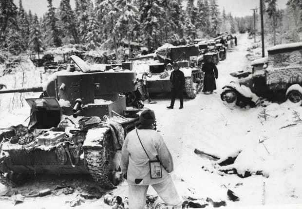
After much debate the Finnish government rejected the offer. On November 30, 1939, the USSR invaded Finland with 450,0000 men. They also began bombing Helsinki. There was no declaration of war, and the act violated several non-aggression pacts. The League of Nations condemned the action and expelled the Soviet Union. The Soviet Union believed that they could easily defeat Finland in a matter of weeks, and some reports suggest that they intended to conquer the entire country.

However, Finland fought back despite being outnumbered and at a disadvantage militarily. The Soviets experienced large numbers of casualties and were thoroughly embarrassed by the end of the first month of the war. Help from the League of Nations never came as Norway and Sweden refused to allow troops passage to Finland.

On March 12, 1940, the 105-day war ended with Finland making an offer to the Soviet Union. They would meet all the demands of the USSR on October 5, in addition they surrendered the entire Karelian Isthmus and a large piece of land north of Lake Ladoga. Part of the Salla region was also ceded to the Soviets. 12% of Finland’s population were evacuated from their homes in order to remain in Finnish territory. The Soviets got everything they wanted without ceding any territory, but they did experience large numbers of casualties during the war.

10 Military Invasions That Changed Global Map In The 20th Century
Map showing the location of East Timor. Wikipedia

1975 Invasion of East Timor

East Timor was a Portuguese colony up until the Japanese occupation of World War II. After the war the Dutch East Indies became independent as the Republic of Indonesia. East Timor went back under the control of Portugal and was known at the time as Portuguese Timor. Then the Carnation Revolution in Portugal led to the Portuguese government deciding to pull away from its colonial possessions.

Political parties quickly formed in East Timor and there was some fighting when the parties split and one gained control of the military. Eventually the military switched sides and the fighting ceased. Despite the fact that the turmoil in East Timor stopped, Indonesia still saw the Portuguese coup as a chance to annex East Timor. Indonesia was not in a position to expand because of domestic political factors but when East Timor’s left-wing political faction won out, they feared that a communist state might form. If East Timor became communist, then it might be in a position to act as base for unfriendly actors to get into Indonesia. Indonesia also claimed that a communist East Timor could be a threat to Western submarines or spread secessionist ideas to Indonesian states.

On December 7, 1975, Indonesia invaded East Timor. 641 paratroopers landed in Dill, where they fought the East Timor military. In 6 hours, they had overtaken the city. On December 10, another invasion captured Baucau. Then on Christmas Day, 10,000 to 15,000 troops arrived in Liquisa and Maubara. The Indonesian troops continued to occupy East Timor and by April 1976, 35,000 soldiers were occupying the state.

The troops loyal to the left-wing party in East Timor were massively outnumbered and therefore fled to the mountains to launch a guerrilla rebellion. The fight for East Timor continued through 1978, until the Indonesian military resorted to brutal tactics to finally suppress the rebellion. A brutal regime would remain in East Timor until 1999.

10 Military Invasions That Changed Global Map In The 20th Century
Map showing Tibet which was annexed to be part of China. Colorofblue.org

1950 Invasion of Tibet

In March 1950, the Tibetan government send a delegation to confer with the newly created People’s Republic of China to get assurances that Tibetan sovereignty would be respected. The dialogue did not happen until September 16 due to a debate between Britain, India, Tibet, and China about where would be the best place to hold the meeting. At the meeting, China told the Tibetan delegation that China had a three-point proposal for Tibet. The proposal stated that Tibet would be part of China, China would be responsible for protecting Tibet, and China would take over trade and foreign policy for Tibet. The delegation wanted to keep China as protector and patron, but they had some stipulations about the proposal, namely that they did not want Chinese troops stationed in Tibet.

As the Tibetan government debated the proposal, Chinese troops entered Tibet on October 7, 1950. The plan for the invasion was to demoralize the Tibetan government by capturing the army in Chamdo and therefore putting pressure on them to negotiate for incorporation into China. The People’s Liberation Army quickly outnumbered the Tibetan forces and captured Chamdo by October 19.

Once the PLA gained complete control over Chamdo, hostilities ceased and one of the captured Tibetan military commanders was sent to the capital to reiterate the terms of negotiation. A delegation was sent to Beijing on October 21 with orders to agree to the first point of the proposal if China would guarantee the status of the Dalai Lama. The delegation was to completely reject the other two points in the proposal.

Eventually the two sides came to the Seventeen Point Agreement which incorporated Tibet into China as an autonomous region under the Dalai Lama. However, in 1955, a “Preparatory Committee for the Autonomous Region in Tibet” was created as a parallel administration that was communist. This caused the Dalai Lama to flee to India. In 1965 the Tibet Autonomous Region was established which made Tibet the equivalent of a Chinese province.

10 Military Invasions That Changed Global Map In The 20th Century
Map showing the disputed areas and sites of major battles. Greatmilitarybattles.com

1932 Invasion of Bolivia

The Paraguayan invasion took place due to the disputed territory of Chaco. The territory had been disputed between the two countries for years but in 1905 Bolivia began moving settlements into the area which was only half-heartedly opposed by Paraguay. In the years following, minor border clashes threatened war between the countries over the disputed border but neither Bolivia nor Paraguay had the military capacity to go to war. It was not until 1932 that both countries had the arms and military for the border dispute to escalate.

The two sides were very mismatched. Bolivia had three times the population and a much larger army. For Bolivia, dispute over Chaco was not worth dying for, and therefore the majority of the population was not affected by the war. For Paraguay the war became a total one; the entire military was mobilized and everyday citizens made sacrifices to support the war effort. Both Bolivia and Paraguay moved forces into the Chaco region which had previously been attributed as part of Bolivia in 1932.

In May 1933, Paraguay officially declared war on Bolivia and the fighting in the border region escalated. Paraguay made substantial gains against the Bolivian forces and the advance continued through 1934. In January 1935 the Paraguayan army moved into undisputed Bolivian territory.

Bolivian forces then gained the upper hand through aggressive counterattacks which led to a truce in June 1935. Throughout the years of fighting, 100,000 men lost their lives and the Bolivian economy suffered. The Chaco Peace Conference in 1938 gave Paraguay control over the majority of the Chaco region, but Bolivia was given a corridor that led to the Paraguay River and the port of Puerto Casado.

10 Military Invasions That Changed Global Map In The 20th Century
Map of Italian invasion of Ethiopia. Slidego.com

1935 Invasion of Ethiopia

In 1934, Ethiopia (then Abyssinia) was one of the few independent states remaining on the African continent. Most of the continent had been parceled up into European colonies, and, despite an attempt by Italy to take over Ethiopia in the 1890s, the country remained independent. Italy never gave up its intentions for the territory and they used a border incident between Ethiopia and Italian Somaliland as an opportunity to finally take control. In December 1934, the border incident caused Benito Mussolini to intervene. Ethiopia tried to arbitrate the incident, but Italy rejected all offers and invaded on October 4, 1935.

The Ethiopian army was outmatched against the Italian forces, they were poorly armed and not well-trained. The Italian air force bombed the cities of Harar and Jijiga on March 22 and both cities were reduced to nothing but ruins. On April 14, the Battle of the Ogaden began with the last of the Ethiopian army. It took ten days for the Ethiopian army to disintegrate, as 5,000 soldiers perished in the battle.

On May 5, the Italian army took the capital of Addis Ababa with little resistance. Emperor Hailie Selassie of Ethiopia went into exile, which promoted Mussolini to proclaim King Victor Emanuel III as emperor of Ethiopia. Ethiopia appealed to the League of Nations for help against Italy. The League condemned the invasion and imposed economic sanctions. The sanctions were not very well supported by member nations and were largely ineffective at halting the Italian aggression in Ethiopia. None of the major powers had an interest in militarily opposing Mussolini.

Ethiopia stayed under Italian control until it was granted its sovereignty following the events of World War II.

Advertisement